IV.1., IV.2. Borneo (General, Kalimantan, Mahakam Delta)
Borneo island consists of an uplifted and deeply eroded Pretertiary core of Mesozoic or older metamorphic rocks and mainly Cretaceous-age granitoid intrusives in the SW part of the island This core is surrounded by Cenozoic accretionary complexes in the North and SE, and by several Cenozoic sedimentary basins.
Until recently the ‘SW Borneo’ core of the island was either viewed as part of the ‘Sundaland’ complex of Gondwana-derived plates that, together with the South China, Indochina, East Malaya and Sibumasu plates, had been part of Eurasia since the Triassic Hartono and Tjokrosapoetro 1986, Metcalfe 1987), or as a separate plate that was derived from the Indochina margin (e.g. Metcalfe 1987?).
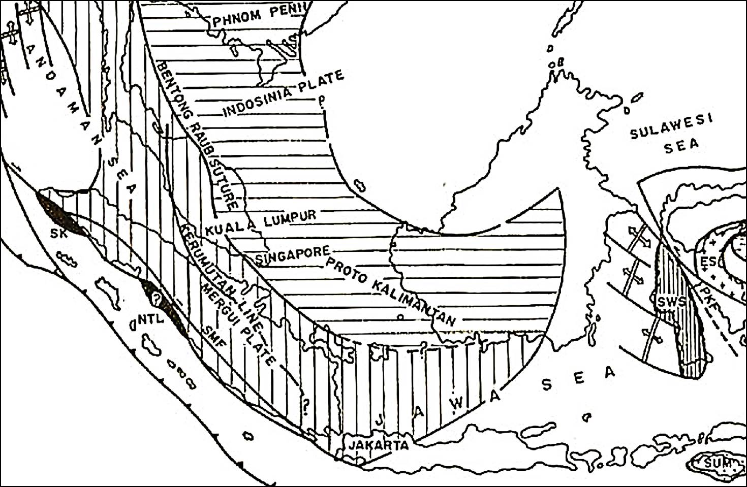
Geologic setting of Borneo island (Hartono and Tjokrosapoetro 1986). In this 'traditional' model, the core of Borneo is part of Triassic Sundaland, an extension of the Indochina plate, possibly also Sibumasu (diamond source?).
More recently SW Borneo was proposed to be a separate microplate that broke off the NW Australia margin as late as Jurassic ('Argoland'; Hall et al. 2009, Metcalfe 2010). This requires that the NW part of Kalimantan is a separate microplate (Semitau Block of Metcalfe (2010), because its geology and Late Carboniferous- Jurassic faunas clearly belong in the 'Cathaysian' realm, not Gondwana. Debate on this will undoubtedly continue.
Paleomagnetic data suggest SW Borneo has been near the equator at least since the Jurassic, and rotated counterclockwise by about 90° since the Jurassic, about 50° since the Cretaceous. These results have been consistent between three generations of independent academic groups and appear rather compelling.
The SW Borneo continental terrane is dominated by the belt of late Early Cretaceous (Aptian- Albian) Schwaner Mts granite batholiths (~100-130 Ma; Williams et al. 1989), which are generally interpreted as the exhumed roots of a volcanic arc system that formed above a South-dipping subduction of Paleo-Pacific or ‘Proto-China Sea’ oceanic plate. This belt probably continues NW to Tambelan and Anambas islands (Williams et al. 1988, Hutchison 2005), then onto the SE Vietnam Dalat zone granitoids, the northern South China Sea and the 'Yanshanian' magmatic arc of SE China
The North side of the SW Borneo continental core is a series of Cretaceous-Miocene accretionary complexes, that become progressivey younger in northern direction. The oldest of these is the (Late Jurassic?-) Early Cretaceous melange of radiolarian cherts, red siliceous shales and ultrabasic rocks (‘Danau Fm’ of Molengraaff, 1910; Figure IV.1.4), also called Semitau/ Selangkai/ Boyan Melange, Kapuas Complex, Telen- Kelinjau melange, etc.) (see also next chapter on N Borneo).
This oldest melange belt may continue East as far as the Mangkalihat Peninsula (Amiruddin 2009), which is often portrayed as a microcontinental block, but nearest Pre-Tertiary outcrops and well penetrations do look more like ‘Danau melange’.
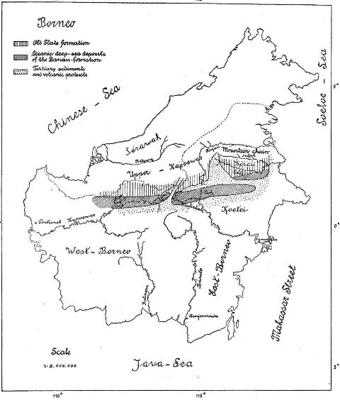
Historic geologic sketch map of Borneo, first describing the distribution of Mesozoic 'Danau Formation' with oceanic deposits by Molengraaff (1909), now known as an Jurassic- Early Cretaceous accretionary complex.
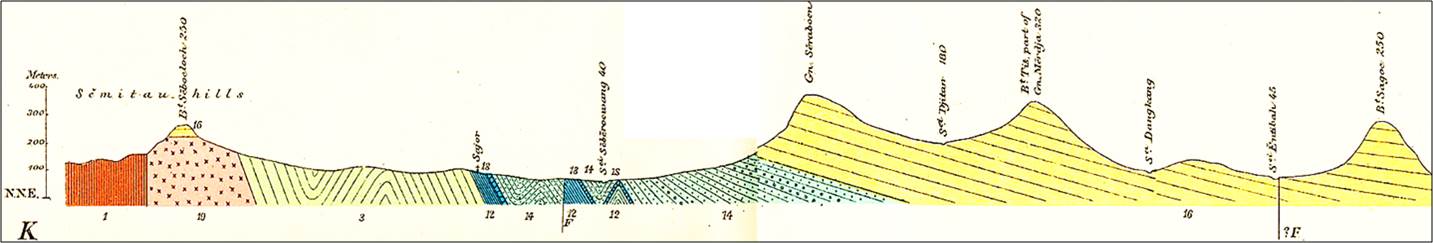
Historic N-S cross-section Semitau area, NW Kalimantan (Molengraaf 1902).
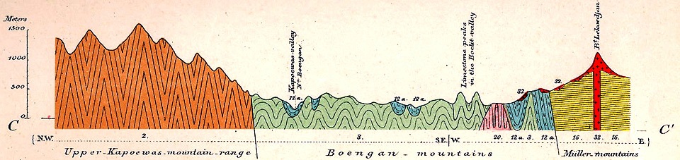
Historic N-S cross-section Sarawak-N Kalimantan border area (Molengraaff 1902). From left: intensely deformed 'Old Slate Fm' of Upper Kapuas Mts (2), folded Mesozoic Danau Fm (3), unconformably overlain by Cretaceous claystone (12a) and Tertiary sandstone Fm (16), overlain by young volcanics (32).
The Meratus Mountains in SE Kalimantan, with its outcrops of melange and serpentinites and associated oceanic crust rocks, have long been regarded as a suture zone between colliding continental blocks at the SE edge of Sundaland. There is indeed evidence of mid-Cretaceous age (~90 Ma) ophiolite obduction, with a blueschist-grade metamorphic sole, but the ophiolite sheet is nearly flat and it is not clear (1) whether the subduction zone was NW or SE dipping, and (2) what collided here (e.g. Wakita ). The present relief of the Meratus Mountains is not the result of of mid-Cretaceous obduction, but represents post-Middle Miocene uplift (transpression?), that does not necessarily parallel the Cretaceous basement grain.
The melange below the ophiolite contains radiolarian cherts, varying in age from early Middle Jurassic to late Early Cretaceous, representing the ages of the pelagic cover scraped off during subduction. This suggests the age of subducted oceanic crust was at least partly older than M Jurassic ('Meso-Tethys' oceanic plate?). Ophiolite obduction in the Meratus Mountains was followed by a period of Late Cretaceous arc volcanism, mainly in a marine environment.
The E-W trending Melawi and Ketungau sedimentary basins formed across C Kalimantan, probably mainly in the Early Tertiary, and may link to the West Kutai basin. The Melawi Basin is probably older than the Ketungau Basin, and the two are separated by the Late Cretaceous 'Boyan melange'/ 'Semitau High'. Heryanto (1991) interpreted these as forearc basins between N-migrating uplifted accretionary prisms, filled with clastics derived from these uplifting Boyan and Lubuk Antu accretionary complexes in the North. Thick sandstones and non-marine and brackish-water facies make dating difficult.
The Kutai Basin of E Kalimantan probably has the thickest sediment fill (12-14 km) of all Indonesian basins. It has been suggested that parts are underlain by oceanic crust (Wain & Berod,1989, Moss 1998). Part of the accommodation was tied to extension during the M Eocene and younger rifting of the Makassar Straits, but parts have to be older.
Significant angular unconformities have been reported from the Kutai and Tarakan basins in the late Middle Eocene and around the Early- Middle Miocene boundary (Achmad & Samuel 1984, Moss 1998, etc.). These two uplift/ early inversion events have been linked to the Luconia and Dangerous Grounds/Palawan continental blocks collisions at the N margin of Borneo.
Most of Borneo island shows evidence of kilometers of young uplift. The Schwaner Mountains granite plutons formed at >6 km depth, and are now in outcrop. Maturation and diagenesis of Early Tertiary sediments in the West Kutai basin, etc., suggest up to 5 km of erosion. The Mount Kinabalu granite rose over 6 km in the last 7 million years. Some of this uplift was early, around the E-M Miocene boundary, much of it is of Pliocene and younger age.
Numerous oil and gas fields have been discovered in the Cenozoic basins and delta systems of East Kalimantan and North Borneo since the discovery of Sanga Sanga field in 1897. Numerous references on these fields and their play elements can be found in the Bibliography. A thorough review of the petroleum geology of the Tarakan Basin is Wight et al. (1993).
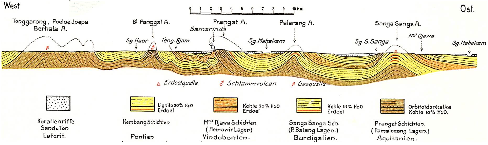
Historic W-E cross-section Kutai Basin showing Middle Miocene and later folding of pre-Middle Miocene deltaic sediments near Samarinda town and the Sanga-Sanga oilfield (Jezler, 1916).
Most of the oil and gas fields in Kalimantan are along the Eastern margin, in the Mahakam and Tarakan delta complexes that prograde into the deep basins of North Makassar Straits and the Celebes Sea. Oil and gas in the deeper horizons are sourced from thermally mature organic-rich deltaic source rocks, while biogenic gas may be present in shallow horizons, sourced from sandstones rich in plant material.
Eocene and Oligo-Miocene carbonates are present in all E Kalimantan basins, but, with the exception of the non-commercial Kerendan gas field in the upper Kutai basin, have not yielded any hydrocarbons.
Finally, several areas of Kalimantan has been known to yield diamonds. They are all in alluvial deposits and their origin is unknown. Some yielded Archean ages (3.1 Ga; Smith et al. 2009) and somehow must have come from a Gondwanan terrane. A series of papers have speculated on their origin, but no definitive answers have been presented yet.
Suggested Reading: Kalimantan (not a complete listing of all relevant papers)
| General, Tectonics |
Molengraaff 1910, Haile 1974, Hartono 1984, 1985, Doutch 1992, Van de Weerd and Armin 1992, Simanjuntak 1999, Tate 2001, Hennig et al. 2017
|
| Paleomagnetic rotations |
Haile et al. 1977, Untung et al. 1987, Schmidtke et al. 1990,Fuller et al. 1991, 1999, Sunata and Wahyono 1991, 1998 |
| Tertiary Stratigraphy |
Leupold and Van der Vlerk 1931, Baumann 1972, Samuel and Muchsin 1975, Achmad and Samuel 1984, Pieters et al. 1987, Tate 1991, Heryanto 1993, 2000 |
| Paleozoic- Mesozoic fauna |
Martin 1888, 1889, 1898, Krekeler 1932, Von Koenigswald 1939, Rutten 1943, 1947, Schairer and Zeiss 1992 |
| Igneous complexes, Minerals |
Williams and Harahap 1986, Williams et al. 1984-1990, Simmons and Brown 1990, Van Leeuwen et al. 1990, Harahap 1993, 1996, Suparka 1995, Abidin and Sukardi 1997, Hartono et al. 1999, Soeria-Atmadja et al.1999, Amiruddin 2009, Prouteau et al. 1996, 2001, Davies et al. 2004, 2008, Hartono 2003, 2006, Robinson et al. 2013 |
| W Kalimantan |
Molengraaff 1902, Wing Easton 1904, Loth 1920, Ter Bruggen 1935, Zeijlmans van Emmichoven 1939, Williams et al. 1986, 1990 |
| Melawi-Ketungau basins |
Martin 1898, Rose and Hartono 1978, Williams et al. 1984, Heryanto 1991-1996, Panggabean 2005, Yulihanto et al. 2006, Passe et al. 2008, Badaruddin et al. 2018ab |
| Tarakan Basin |
Samuel 1980, Achmad and Samuel 1984, Wight et al. 1993, Biantoro et al. 1996, Lentini and Darman 1996, Darman 1999, Noon et al.2003, Subroto et al. 2005, Sukanta et al. 2009, Sudarmono et al. 2017, Saputra et al. 2018 |
| Kutei Basin |
>Ubaghs 1936, Samuel and Muchsin 1975, Panigoro 1983, Nuay et al. 1985, Land and Jones 1987, Ott 1987, Van de Weerd et al. 1987, Moss 1988, Sunaryo et al, 1988, Wain and Berod 1989, Biantoro et al. 1992, 1994, Saller et al. 1992, 1993, Sardjono and Rotinsulu 1992, Chambers and Daley 1995,1997, Bates 1996, Stuart et al. 1996, Tanean et al. 1996, Paterson et al. 1997, Endharto 1997, Ferguson and Clay 1997, Paterson et al. 1997, Cloke et al. 1997, 1999, Moss 1998, Moss and Finch 1998, Guritno and Chambers 1999, Moss and Chambers 1999, Chambers and Moss 1999, Feriansyah et al. 1999, Saller and Vijaya 2002, Chambers et al. 2004, Ca |
| Mahakam Delta |
Gerard and Oesterle 1973, Allen et al. 1976, 1979, Loiret and Mugniot 1982, Carbonel and Moyes 1987, Allen and Chambers 1998, Allen and Mercier 1988, Duval et al. 1998, Sidi et al. 1998, Peters et al. 1999
McClay et al. 2000, Nummedal et al. 2000, Peters et al. 2000, Snedden et al. 2001,Lambert et al. 2003, Roberts and Sydow 2003, Subroto et al. 2006, Cibaj et al. 2007- 2010, Lambiase et al. 2017
|
| Barito basin |
Hooze 1893, Verbeek 1875, Krol 1920 1925, Siregar and Sunaryo 1980 Campbell and Ardhana 1988, Kusuma and Darin 1989, Mason et al. 1993, Rotinsulu et al. 1993, Satyana et al. 1993-2002, Bon et al. 1996, Heryanto and Panggabean, 2004, Heryanto 2010, Witts 2011, 2013, Witts et al. 2014, Kristyarin et al. 2016 |
| Meratus Mts |
Martin 1889, Retgers 1893, Krol 1920, Rutten 1926, Priyomarsono 1986,Sikumbang 1986, 1990, Situmorang 1987, Yuwono et al. 1988, Hardjadinata 1995, Dirk 1995, 1997, 2000, Zulkarnain et al. 1995, 1996, Robinson et al. 1996, Wakita et al. 1997, 1998, 2000, Koji et al. 1998, Parkinson et al. 1998, Monnier et al. 1999, Pubellier et al. 1999, Hartono et al. 1999, Heryanto 2000,Hartono 2000, Abidin and Hakim 2001, Heryanto et al. 2001, 2003, Heryanto and Hartono 2003, Setyanta and Setiadi 2006, Satyana and Armandita 2008, Satyana 2010, Heryanto and Panggabean 2010, Hartono 2012, Soesilo et al. 2012, Setiawan et al. 2014 |
| Oil and gas fields |
Courteney et al. 1991 and too many others to include here; see bibliography |
| Diamonds |
Posewitz 1885, Wing Easton 1894, 1933, Doorman 1906, Krol 1922, Hovig 1930, Witkamp 1932, Koolhoven 1933, 1935 Ubaghs 1941, Bergman et al. 1987, 1988, Taylor et al. 1990, Spencer et al. 1988, Burgath and Mohr 1991, Tay et al. 2005, Aziz 2007, 2014, Smith et al. 2009, Van Leeuwen 2014, Kueter et al. 2016, White et al. 2016, Shen et al. 2017 |
IV.3. North Borneo (Sarawak, Sabah, Brunei)
The sub-chapter IV.3 contains 930 references on the geology of Sarawak, Sabah and Brunei. Many papers discuss oil and gas fields, deepwater and deltaic sedimentology, ophiolites, micropaleontology, etc..
Except for SW Sarawak, which is a continental area with Late Paleozoic and Mesozoic sediments of Indochina affinity, the geology of onshore North Borneo is dominated by a series of W-E to SW-NE trending accretionary complexes and large younger delta systems that are home to many oil and gas fields.
The accretionary complexes are composed of intensely folded, predominantly South-dipping, imbricated deep water sediments of Cretaceous to Middle Miocene age, with fragments of ophiolitic rocks. These demonstrate that the North Borneo margin was a long-lived active margin, with subduction of 'Proto-South China Sea' oceanic crust to the South, under Kalimantan/ Sundaland, creating E-W trending volcanic arc systems in Kalimantan. This subduction zone may be traced Westward towards the Natuna- Anambas islands, and possibly links to the N Vietnam- SE China ' Yenshanian' magmatic arc.
The long duration of subduction suggests subduction of a large oceanic plate. The presence of latest Jurassic and Early Cretaceous age radiolarian chert blocks in the accretionary prism (Jasin 1996, 2000) suggest the subducting ocean crust was of Late Jurassic or older age. It was therefore probably not a South China Sea-type marginal basin, but may have been part of an early Pacific Ocean sea floor (Aitchison 1994, Honza et al. 2000).
Multiple accretionary complexes have been distinguished and named, younging in N direction. The oldest complex is mainly in North Kalimantan and was called the Danau Formation by Molengraaff (1910), who already recognized these folded radiolarian cherts, red siliceous shales and ultrabasic rocks as oceanic deposits. It is of (latest Jurassic?-) Early Cretaceous age. In the North Kutai Basin this is known as Telen- Kelinjau melange.
Further North, straddling the Kalimantan- Sarawak border, is the Late Cretaceous (Santonian) - Early Eocene Rajang- East Crocker Belt (Embaluh Group in Kalimantan). It is unconformably succeeded in onshore Sarawak and Sabah by the Late Eocene- Early Miocene West Crocker Belt.
The closing of the ocean basin was probably diachronous, and was punctuated by microplate collisions, like the Luconia/ Miri Block collision, which caused a Middle-Late Eocene uplift event in onshore N Borneo (‘Sarawak Orogeny’).
Subduction and arc volcanism ceased completely by the end of the Early Miocene (~16 Ma), after collision of the Dangerous Grounds-Palawan Block ('Sabah orogeny'). This also stopped the opening of the South China Sea and caused uplift across much of N Borneo- Kalimantan, leading to major acceleration of progradation of deltas around the E-M Miocene boundary in Sarawak and the Tarakan, Kutai and Barito basins in Kalimantan.
Except for the large and shallow Miri oil field of North Sarawak, discovered in 1910, all North Borneo oil and gas discoveries are offshore.
Useful recent summaries of North Borneo hydrocarbon provinces are in Sandal et al. (1996) and Petronas (1999). Two main hydrocarbon play areas may be distinguished:
- the oil-prone Middle Miocene- Early Pliocene Baram Delta system in the East (off Brunei- Sabah)
- the gas-prone Central Luconia Province in the West (off W Sarawak), with Oligocene sandstone and Middle- Late Miocene carbonate reservoirs.
Suggested reading: North Borneo (not a complete listing of all relevant papers)
| Text Books |
Liechti et al. (1960), Sandal et al. (1996), Hutchison (2005) |
| Tectonics, Regional |
Kirk 1968, Haile 1969, McManus and Tate 1983, Levell 1987, Hutchison 1988-2010, Tjia 1988, Hinz et al. 1989, Rangin et al. 1990, Tongkul 1990-2006, Tate 1992, Hazebroek and Tan 1993, Tongkul 1994, Omang 1994, 1995, 1996, Swauger et al. 1995, 2000, Omang and Barber 1996, Clenell 1996, Milsom et al. 1997, Ismail 1999, Leong 1999, Balaguru et al. 2003, Morley et al. 2003, Tingay et al. 2005, 2009, Morley and Back 2008, Balaguru and Hall 2009, Cottam et al. 2010, Cullen 2010, King et al. 2010, Hall 2015, Wang et al. 2016, Lunt and Madon 2017ab, Rahim et al. 2017, Tongkul 2017 |
| SW Sarawak Paleozoic- Mesozoic |
Cummings 1961, Bayliss 1966, Sanderson 1966, Kon'no 1972, Tamura and Hon 1977, Fontaine 1990, Beauvais and Fontaine 1990, Vachard 1990, Jasin and Said 1999, Jasin 2000, Takuya and Takeshi 2002, Sakamoto and Ishibashi 2002, Breitfeld et al. 2017, 2018, Breitfeld and Hall 2018 |
| Accretionary complexes |
Molengraaff 1910 (Danau Fm), Stauffer 1967, Tan 1982, Benard et al. 1990, Aitchison 1994, Hutchison 1994, 1996, Tongkul 1987-2006, Harahap 1995 (Boyan), Moss 1998 (Embaluh), Honza et al. 2000, Crevello 2001, Van Hattum et al. 2003, 2006, Lambiase et al. 2008, Galin et al. 2017 |
| Hydrocarbons- Mio-Pliocene clastics |
Redfield 1922, Wilford 1961, Schaar 1976, Rijks 1981, Johnson et al. 1989, Ismail et al. 1995, Koopman and Schreurs 1996, Carter et al. 1997, Mat-Zin and Swarbrick 1997, Schreurs 1997, Graves and Swauger 1997, Tan et al. 1999, Bait 2003, Darman and Damit 2003, Saller and Blake 2003, Ingram et al. 2004, Jong et al. 2017, Kessler and Jong 2017, 2018 |
| Hydrocarbons- Luconia carbonate play |
Ho Kiam Fui 1978, Epting 1980, 1989, Doust 1981, Ho 1990, Madon and Hassan 1999, Vahrenkamp et al. 1998, 2004, Ho et al. 2003, Bracco et al. 2004, Zampetti et al. 2004, Kob and Ali 2008, Chung and Ghosh 2017, Clark et al. 2017, Janjuhah et al. 2017 |
| Mt Kinabalu granite |
Collenette 1958, 1964, Roe 1964, Jacobson 1970, Kasama et al. 1970, Vogt and Flower 1989, Hoppe 1990, Hall et al. 2008, Sperber 2009, Swauger et al. 2000, Cottam et al. 2010, 2013, Burton-Johnson et al. 2013, 2017 |
IV.4. Makassar Straits
This sub-chapter IV.4 of Bibliography 7.0 contains 128 references to papers on the geology of the Makassar Straits area.
Makassar Straits represents an Eocene rift system between East Kalimantan and West Sulawesi, which formed at the eastern margin of Sundaland, and in the process probably separated a continental sliver terrane from this margin that is now West (and part of North?) Sulawesi.
The deep water Makassar Straits basin today is a major faunal dividing line (Wallace's Line) in SE Asia, separating predominantly Asian flora and fauna to the West and Australian-type dominated fauna and flora in the East. With water depths locally over 2000m, it is also the main pathway of deep waters flowing from the West Pacific Ocean to the NE Indian Ocean ('Indonesian Throughflow; see also Volume I).
There is ongoing debate on whether and how much of Makassar Straits is underlain by oceanic crust versus highly extended continental crust (e.g. discussions in Hall et al. 2009, Satyana 2015)
The three main hydrocarbon plays in and along the Makassar Straits are, in order of importance:
- Miocene- Pliocene delta systems in the North Makassar Basin along the East Kalimantan margin (Mahakam-Kutai, Tarakan Basins): with numerous large onshore and offshore discoveries, mainly in young anticlines in Miocene- Pliocene fluvial-deltaic deposits;
- Plio-Pleistocene deep water submarine fans and slope channels sandstone reservoirs off the East Kalimantan margin. These are relatively small discoveries of biogenic gas, sourced from sandstones rich in delta-derived plant material. Until now this play is limited to the western slope and basin margin of the North Makassar Straits basin, in front of the East Kalimantan delta systems. Fields include West Seno, Ganal, Merah Besar, Gendalo and Ranggas. (Dunham 2016);
- The 'traditional' Sundaland Paleogene rift-basin plays in South Makassar Straits, in Oligo-Miocene post-rift fluvio-deltaic clastics and overlying carbonate buildups. Several relatively small oil and gas fields (Makassar Straits/ Takatuka gas field).
Suggested reading: Makassar Straits (not a complete listing of all relevant papers)
| Tectonics |
Hamilton 1979, Burollet and Salle 1981, Situmorang 1977, 1982, 1989, Untung et al. 1985, Cloke 1997, Cloke et al. 1999, Fraser and Ichram 1999, Guntoro 1999, 2000, Wijaya and Kusnida 2009, Moss et al. 2000, Fraser et al. 2003, Lin et al 2005, Nur'Aini et al. 2005, Puspita et al. 2005, Hall et al. 2009, Courel et al. 2011, Baillie and Decker 2012, Satyana et al. 2012, Lunt and Van Gorsel 2013, Satyana 2015, Bernando et al. 2017 |
| Deep water hydrocarbon exploration |
Lumadyo 1999, Musgrove et al. 1999, Saller et al. 2000, Guritno et al. 2003, McKee and Dunham 2006, Sawada et al. 2007, Sugiaman et al. 2007, Heri et al. 2009, Siregar et al. 2010, Bacheller et al. 2011, Satyana 2015, Dunham 2016. |