This chapter VI of Bibliography Ed. 7.0 deals with the northernmost part of the Indonesian Archipelago. It contains 67 pages, with 423 titles. It is subdivided into three chapters:
VI.1. Halmahera, Bacan, Waigeo, Molucca Sea
VI.2. Banggai, Sula, Taliabu, Obi
VI.3. Seram, Buru, Ambon
The North Moluccas comprise the area between Sulawesi and West Papua and are a geologically complex region with a number of active volcanic arcs, non-volcanic 'outer arcs', fragments of remnant arcs, microcontinents, and deep basins floored by oceanic crust.
The attached pdf consists of both a detailed bibliography as well as lengthy introductions for each of the sub-chapters.
VI.1. North Moluccas (Halmahera, Bacan, Waigeo, Yapen, Molucca Sea)
Sub-chapter VI.1. contains 155 references on the geology of the Halmahera region.
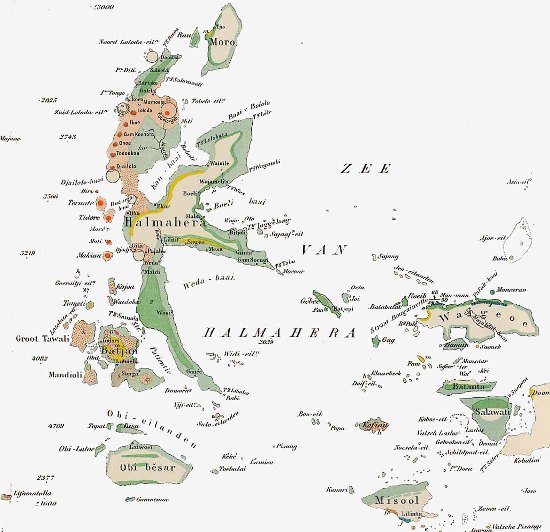
Early geologic map of Halmahera- Bacan - Waigeo (Verbeek 1908)
This area of N Indonesia is in the realm of the western Pacific Ocean (Philippine Sea Plate). The western part is the Molucca Sea complex, where Molucca Sea Plate oceanic crust is subducting in two directions, under Halmahera in the East and the Sangihe arc in the West. The S side is bordered by the Sorong Fault zone, a major strike slip zone separating the W-moving Pacific from a N-moving Australia- New Guinea plate.
Islands are composed of fragments of Late Cretaceous- M Eocene and younger island arc volcanics, intruded into and overlying collisional complexes with Jurassic or Cretaceous-age ophiolites. With the exception of parts of islands in the Sorong fault zone complex, no Pre-Tertiary sediments or continental crust material have been reported.
The K-shaped island of Halmahera may be viewed as a similar, smaller and younger edition of Sulawesi. In both islands the western arms represent a Neogene volcanic arc system, while the central region and eastern arms contain large ophiolite complexes and interlayered sediments, while the arms are separated by young extensional basins.
The West Halmahera Arc is composed of Late Miocene- Quaternary andesites with subordinate basalts, and is a response to the East-ward subduction of the Molucca Sea Plate at the Halmahera Trench (Hakim and Hall 1991).
The Molucca Sea is a rare modern-day example of a ‘double-dipping’ oceanic plate, dipping westward under the Sangihe Trench/Arc in the West and eastward under the West Halmahera Trench/Arc in the East . Most of the Moluccas Sea oceanic crust has actually been consumed, and the Molucca Sea floor is an area of an arc-arc collision-in-progress (Silver and Moore 1978, 1981, Cardwell , Hamilton 1979, McCaffrey 1982, 1991).
The collision zone is composed of two accretionary complexes of opposing vergence, with slivers of ophiolites. The Talaud Islands represent an uplifted part of the accretionary/ melange complex of the collision zone (Atmadja, and R. Sukamto, 1979, Sukamto 1980).
The Talaud Islands are exposed parts of the N-S trending Central Ridge, which is entire composed of an imbricated accretionary prism/ melange complex, with ophiolitic blocks in a scaly clay matrix, (Soeria-Atmadja and Sukamto 1979, Moore et al. 1980, 1981).
Suggested Reading: Halmahera area (not a complete list of all relevant references)
Sukamto et al. 1981, Morris et al. 1983, Hall 1987, 1999, Hall et al. 1988, 1990, 1995, Hakim and Hall 1991, Sukamto 1989, Ali et al. 2001, Sodik et al. 1993.
Molucca Sea
Silver and Moore 1978, 1981, McCaffrey et al. 1980, 1982, 1991, Moore and Silver 1983, Widiyantoro 2003, Widiwijayanti et al. 2003, 2004.
Talaud islands
Roothaan 1928, Sukamto and Suwarna 1976, 1979, Soeria-Atmadja and Sukamto 1979, Sukamto 1980, Moore et al. 1980, 1981, Bader and Pubellier, 2000.
Sangihe Arc
Wichmann 1921, Morrice 1982, MacPherson et al. 2003.
VI.2. Banggai, Sula, Taliabu, Obi
Sub-chapter VI.2. contains 79 references on the geology of the Banggai and Sula archipelagoes. This group of islands west of the Birds Head of West Papua is generally believed to represent one or more microcontinental plates, that sliced off the northern margin of New Guinea in Jurassic time.
Early geological investigations on the Sula islands included Boehm (1904, 1907, 1912) and Brouwer (1921). Early papers on the nearby Obi islands are by Brouwer (1924). The Obi islands appear to contain some Jurassic sediments overlying Triassic- Jurassic? ophiolites and metamorphics.
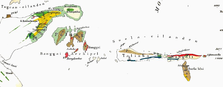
Early geologic map of Banggai- Sula islands (Verbeek 1908)
The Sula islands lent their name to the 'Sula Spur' of Klompe (1954, 1956), who viewed the Banggai, Sula and Obi islands region as the remnants of the western termination of the Australian-New Guinea Paleozoic ('Tasmanide') fold belt, and which acted as the leading edge of the Australia-New Guinea plate during during Tertiary colllisional movements. Structure of the main Sula islands (Taliabu, Mangoli) is rather simple (some block faulting, gentle N-ward dip).
Basement of the Banggai-Sula block consists of Paleozoic metamorphic rocks, overlain by Triassic arc volcanics (Mangole Fm) and intruded by co-magmatic granite batholiths (Banggai granite; K-Ar ages around 225 Ma). These Triassic intrusives and volcanics form part of a long Permo-Triassic arc system that continues East to New Guinea Birds Head (Netoni, Anggi granites), to terranes in northern Papua New Guinea (Idenburg, Kubor, Strickland granites; all ~220-240 Ma) and all along the East Australian active margin (Amiruddin 2000, 2009, Ding et al. 2011).
Outcrops of late Middle-Late Jurassic- Cretaceous marine sediments are relatively widespread, and the Sula Islands have long been famous for the richest Jurassic ammonite, belemnite and mollusc faunas in Indonesia (see also Garrard et al. 1988):
the basal ('syn-rift'?) transgression is probably of Middle Jurassic age (Toarcian?; Bajocian; Panuju 2011), and consists of the non-marine Bobong Formation, which contains some thin coal beds (Kusnama et al. 2007, 2008, Septriandi et al. 2012);
the (late-rift?) Middle Jurassic- Lower Cretaceous (Hauterivian?; Garrard et al. 1998) open marine Buya Formation is ~1200m thick and its suggested age include: Late Toarcian- Tithonian by Sato et al. (1978; macrofossils), Bathonian and younger (Westermann and Callomon 1988; ammonites). and Bathonian- Early Tithonian (Lelono and Nugrahaningsih 2012; dinoflagellates);
the overlying Cretaceous bathyal pelagic carbonates of the Tanamu Formation appear to be restricted to Late Cretaceous age (Coniacian- Late Paleocene; Pigram et al. 1985, Garrard et al. 1998, Coniacian- Campanian?; Panuju et al. 2011).
Pigram et al. (1985) noted that the Mesozoic stratigraphy of the Sula Platform was closer to that of Central Papua New Guinea between 141°-145° than to West Papua, implying a westward displacement of >2500 km.
An apparent significant mid-Cretaceous between (>30-40 Myrs?) between clastic Buya Formation and the overlying Tanamu Fm pelagic carbonates was interpreted as a breakup unconformity by Garrard et al. (1998). This is significantly later event than the suggested Middle- Late Jurassic breakup event in Buru and Seram? (e.g. Pigram and Panggabean 1983).
Most of the Jurassic and Cretaceous was eroded in Early Paleogene time from the Banggai archipelago in the West. This event was followed by a likely Late Eocene trangression (with Lacazinella in Tiaka wells and at several localities in the Tomori area of East Sulawesi (Handiwiria 1990) that initiated widespread Late Eocene- Middle Miocene carbonate deposition of the pre-collisional Salodik Formation (Garrard et al. 1998).
Classic paleontological monographs on the Sula Jurassic macrofaunas include Boehm (1904-1912), Kruizinga (1921, 1926, belemnites, ammonites) and Challinor and Skwarko (1982; belemnites) and Westermann and Callomon 1988 (ammonites).
The western edge of the Banggai-Sula plate collided with East Sulawesi, probably in Late Miocene time, by 'underthrusting' of the East Sulawesi ophiolite complex. Imbricated packages that were scraped off the downgoing Banggai Sula plate can be studied in outcrop in the Tomori area of the south side of the East Arm of Sulawesi.
The foredeep subsidence that preceded the collision set up favorable conditions for maturation and trapping of hydrocarbons. Initial subsidence created a backstepping series of Miocene carbonate platform and buildup facies. After burial by collisional and post-collisional 'Sulawesi molasse' these became the oil-bearing reservoirs of the Tiaka, Senoro fields in the Tomori Basin and adjacent onshore East Sulawesi
Suggested Reading: Banggai-Sula area (not a complete list of all relevant references)
General, Tectonics
Verbeek 1908, Wichmann 1914, Brouwer 1915, 1921, 1926,Koolhoven 1930, Klompe 1954, 1956, Sukamto 1975, Pigram et al. 1985, Ryacudu et al. 1993, Kadarusman et al. 1994, Natawidjaja, and Kadarusman 1994; Garrard et al. 1998, Walperdorf et al. 1998, Sardjono 1999, 2007, Amiruddin 2000, Nasution et al. 2008 .
Jurassic stratigraphy/ paleontology
Boehm 1904, 1907, 1912, Jaworski 1921, Kruizinga 1921, 1926,
Sato et al. 1978, Westermann et al. 1978, Challinor and Skwarko 1982, Westermann and Callomon 1988, Sukamto and Westermann 1992, Francis and Westermann 1993, Oloriz, and. Westermann 1998, Pessagno and Meyerhoff Hull 2002, Kholiq et al. 2011, Panuju 2011Lelono and Nugrahaningsih 2012, Septriandi et al. 2012.
Obi
Martin 1904, Wanner 1913, Brouwer 1924, Kuenen 1942, Permana 1987, Soeria-Atmadja et al. 1988, Agustiyanto 1998, Dipatunggoro 2011, Khadafi et al. 2013, Rahmalia et al. 2017.
VI.3. Seram, Buru, Ambon
Sub-chapter VI.3. contains 189 references on the geology of Seram and nearby islands Buru and Ambon.
Seram and the chain of islands continuing in E/ SE direction all share a very complex fold-thrust belt geology, with N-directed thrusting and with fragments of continental blocks, metamorphic rocks and ophiolite complexes. Deformation is less intense West of Seram, on Buru island. Large ophiolite bodies and metamorphic complexes are present in SW Seram and Buru.
Counterclockwise rotation of the Buru-Seram microplate has been suggested by paleomagnetic data (Haile 1978, 74° since Late Miocene) and structural analysis (Linthout et al. 1991; 45° since Early Pliocene).
Seram is home to three or four metamorphic complexes (Kobipoto, Saku, Tehoru, Taunusa; Sopaheluwakan et al. 1992). Interpretation of these has always been difficult, partly due to the wide range of radiometric ages, most of which are suspect (Davies and Tommasini, 2000). Some of the metamamorphics are presumably of pre-Late Triassic age, some have Miocene- Pliocene colling ages and were thought to have formed during Miocene ophiolite obduction (Helmers et al. 1989, Sopaheluwakan 1994). Recent re-interpretations by Pownall et al. (2013-2018) explain much of the metamorphic complexes as result of young hyper-extensional mantle exhumation during the opening of the Banda Sea and roll-back of the Banda Arc slab.
Paleozoic metamorphics are overlain by folded Late Triassic (Carnian-Norian) Kanikeh Fm flysch-type clastics, composed of micaceous sands and shales with plant fragments, Monotos salinaria, etc. This series has been interpreted as the basal part of a Late Triassic intra-cratonic rift sequence.
The clastics are capped by (partly interbedded with?) latest Triassic reefal and deepwater limestones of the Manusela and Saman Saman Formations (late Norian- Rhaetian; Al-Shaibani et al 1983). Reefal facies are rich in calcareous sponges corals and hydrozoans. The Late Triassic limestone of Seram is frequently reported as of Jurassic age, an idea started by Van der Sluis (1950) and Van Bemmelen (1949), although all paleontological evidence points to latest Triassic ages only (Wanner et al. 1952, Martini et al., 2004, Charlton and Van Gorsel 2014).
Above the Late Triassic the Early-Middle Jurassic is either highly condensed limestone (e.g. Wanner and Knipscheer 1951; 60 cm) or is missing completely and Late Jurassic marine Kola Shale directly overlies the Triassic. This hiatus/unconformity was suggested to represent a 'post-breakup unconformity' and signify onset of nearby oceanic spreading (Pigram and Panggabean 1984).
The latest Jurassic-Eocene interval is represented by reddish pelagic limestones (Nief Fm), devoid of any clastic material, and probably representing the oceanic drift or very distal passive margin stage of the Buru- Seram microplate. The basal radiolarian chert-rich limestones contain locally abundant latest Jurassic-earliest Cretaceous calpionellids (mainly Stomiosphaera moluccana; Wanner 1940), and are overlain by Upper Cretaceous limestones without chert and with Globotruncana and above this also Paleo-Eocene planktonics, including Globorotalia velascoensis and Hantkenina (Germeraad 1946).
Similarities in stratigraphy and structure between Seram and Timor have been noticed by many authors. There are also similarities with the Triassic stratigraphy of nearby Misool, but the Jurassic- Paleogene of Seram- Buru is in more distal facies, and lack the rich macrofossil faunas of Misool. There is also evidence of consumed oceanic crust between Misool and Seram, so the present-day proximity is not necessarily the same as the paleo-position(s).
Widespread folding and thrusting of Eocene and older rocks, with the formation of the 'Salas Block Clay' olistostrome or melange, suggests a major collisional event, but the exact age of this remains uncertain. It is probably related to ophiolite obduction at the S/SW side of Seram, which have a Late Miocene onset of exhumation age (around 8 Ma; Linthout et al. 1996).
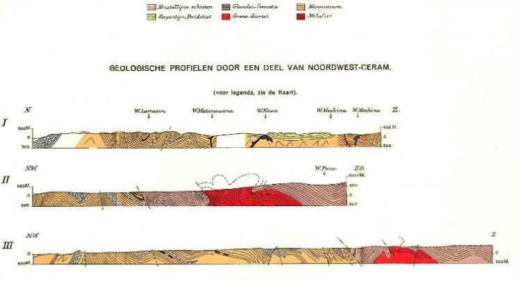
N-S cross-sections through NW Seram, showing N-directed folding and thrusting of metamorphics- granite (pink-red) complex over folded Mesozoic sediments (mainly Late Triassic; light brown 'flysch' and blue limestones) (Rutten and Hotz, 1919)
Deep marine marls as young as Early Pleistocene outcrop on Seram island and suggest about 2 km of Pleistocene-Recent uplift in SW Seram (De Smet et al., 1989).
Oil has been produced from Plio-Pleistocene sands in NE Seram since 1897 (Bula Field), and is believed to be sourced from Late Triassic bituminous shale. Much later oil was also discovered in fractured Late Triassic limestones (Oseil field). Oils from surface seeps and the Oseil and Bula oil fields were sourced from Late Triassic basinal limestones- calcareous shales, derived from Type II marine algae (no terestrial organic material), deposited in anoxic conditions (Peters et al. 1999, Wahyudiono et al. 2018).
The geology of Buru Island shows very similar Triassic- Eocene stratigraphy to Seram but is in a less complex tectonic setting (Wanner 1907, Hummel 1923, Tjokrosapoetro and Budhitrisna 1982, 1983, etc.)
Of particular interest is the presence of Late Triassic 'asphalt shale' in outcrops near Bara-Bai, rich in ammonites and with 23% organic matter (Kossmat 1906, Von John 1906, Krumbeck 1913).
Suggested Reading:Seram- Buru area (not a complete list of all relevant references)
Seram General, Tectonics
Wanner 1907, 1923, Verbeek 1908, Brouwer 1919, Rutten and Hotz 1918-1920, De Jong 1923, Rutten 1927, Germeraad 1946, Valk 1945, Van der Sluis 1950, Audley-Charles and Carter 1977, Haile 1978, Audley-Charles et al. 1979,Tjokrosapoetro and Budhitrisna 1982, De Smet et al. 1989, Linthout et al. 1989, 1996, Kemp and Mogg 1992, Sopaheluwakan et al. 1992, 1994, Supandjono 1994, O'Sullivan et al. 1985, Hadiwisastra et al. 1996, Kemp et al. 1996, Monnier et al. 2003, Hill 2005, Bachri 2011, Hill 2012, Pownall et al. 2013, 2014, 2015,2017, 2018.
North Seram fold-thrust belt
Audley Charles and Carter 1977, Jongsma et al. 1989, Pairault et al. 2003, Teas et al. 2009, Riadini et al. 2010, Darman and Reemst 2012, Sapiie et al. 2012, 2013, Adlan et al. 2016, Patria and Hall 2017.
Wilckens 1937, Wanner et al. 1952, Kemp 1992, Al-Shaibaini et al. 1983, 1984, Martini et al. 2004, Charlton and Van Gorsel 2014.
Oil field(s)
Zillman and Paten 1975ab, Kemp 1992, Moyle et al. 2000, Nilandaroe et al. 2001, Lapulisa et al. 2012.
Source rocks, Oils
Price et al. 1987, Peters et al. 1999, Adlan et al. 2018, Wahyudiono et al. 2018.
Buru
Martin 1902, 1903, Kossmat 1906, Von John 1906, Wanner 1907, 1923, Gerth 1910, Krumbeck 1913ab, Henny 1922, Hummel 1923, Fortuin et al. 1988, Harahap 2002, Hakim and Harahap 2003, Harahap and Poedjoprajitno 2006.
Ambon
Verbeek 1899, 1900, 1905, Boehm 1905, 1908, Brouwer 1925, 1927, Jaworski 1927, Kuenen 1949, Priem et al. 1978, Menzie et al. 1997, Honthaas et al. 1999, Hammarstrom et al. 2013.